Leave Calvi on the busy T30 (N197) heading north. At the second roundabout you will pass Camp Raffalli on your right. This is home to 2e REP - the French Foriegn Legion parachute regiment. You may have seen legionnaires in Calvi wearing their distinct white hats - képis blanc -or maybe you will see them parachuting from high above as part of their basic training. Unless you plan to join up, keep on towards Lumio which perches on the hillside at the end of the long straight. The road starts to climb now and once past Lumio take the right, D71 for Lavatoggio and Cateri. This is a lovely scenic section of the ride with the Med down on the left and the hills rising to mountains on the right. At the Cateri cross roads take a right onto the D151. The gradient picks up now as you head for the communication masts that come into vision now and then atop the Col de Salvi at 528m. The road levels out for a short while and there are great views of your start point, Calvi and its bay - good photo stop.
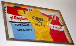
Soon the road will start to descend - narrow with a rugged surface. You're heading for the village of Montemaggiore and the new vista opening up in front of you is the Cirque de Bonifatu with the Monte Grosso massif rising to more than 2000m. This is GR20 country, one of Europe's and most famous long distance walks. The route follows the Bonifatu bowl through the village of Zilia, famous for it's spring water past Domaine Alzipratu (excellent rosé) and onto Calenzana. This is a great place to stop and soak up village life in the Piazza Communa. An optional excursion from here is 3.5km up to the auberge A Flatta. This is signposted and the route is up and out the back of town. The road is not surfaced the entire way but it's worth the effort because of the location and to see some of Jacques Anquetil's memorabilia. A Flatta is run by Sophie, the daughter of one of France's most famous ever cyclists. It's a superb spot and an intriguing story captured well in Paul Howard's book, Sex, Lies and Handlebar Tape. From Calenzana left as you leave town onto the D51 and amble over to Suare and follow airport road back to the T30 (N197) and Calvi. © M.Lund 2013-24
|
